Wednesday, March 13, 2013

3/13/13 Bad Weather For Sweet Sistene

At 4pm (Italy time) the current weather condition in Rome, Italy was rain showers with a temperature of 48°F. Since voting for the new pope began on Tuesday, NBC confirms that the first two conclave votes to elect a new Pope were inconclusive, thus, not resulting in a new pope. While there are no favorites in this race, bets are being made. In Europe, they have a Sweet Sistene betting system (similar to how the college basketball Sweet Sixteen brackets work in the U.S.), for who will end up winning the papalship. Could Mother Nature have some money on this? Hear me out. Last month, when the previous pope resigned, lightning struck the Vatican. Sign from above? Probably not. Just like the Empire State Building, Sears Tower, and the Burj Khalifa alike, the Vatican is a tall building, and often gets struck by lightning. Still, some people saw this as a sign. If you were one of them, get ready for more signs.

Courtesy: Weather.com
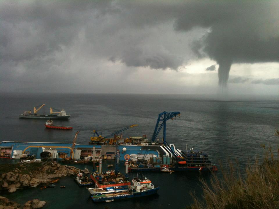
When the Papal Conclave convened yesterday to start the voting process, thunderstorms rolled into Rome, and accorindg to Accuweather, brought several rounds of heavy rain, lightning, and even hail to the Vatican. If that wasn’t enough, a waterspout was reported yesterday just off Isola del Giglio, an island off the coast north of Rome.

Courtesy: Blitzortung.org
Courtesy: GiglioNews

Coincidence or rare occurance? While I can’t say it is a coincidence, it certainly is not rare for Italy to experience thunderstorms in the Spring. In fact, the weather in Rome is filled with hail, heavy rain, and lightning during the Spring months. However, some felt differently about the type of storms they were having. A tweet from Wendy Lou Who says that MSNBC’s reporters mentioned that during their coverage of the conclave that there was “thunder, lightning, and Biblical rain”.

Many stand at the Vatican waiting for an answer with their umbrellas in hand. More rain is expected through the evening tonight, quite heavy at times. Rain will continue Thursday as well, before finally tapering off before Friday morning. So whether or not all of this bad weather is a sign, I cannot say. What I can say is that more of it is likely.


Sources: Accuweather, Weather Channel, ABC News, NBC News, Twitter, Blitzortung

Monday, March 4, 2013

3/4/13 Tornado Scale In Pictures

Often times when a tornado has been confirmed for a certain city/area, you will hear the rating that is given for it as well. This rating is used to let people know how bad of a tornado it was. The scale is called the Enhanced Fujita Scale, and it goes from zero to five, with an EF5 being the worst tornado damage and highest wind speeds. However, sometimes it is hard to visualize what that damage can look like. So above and below are images that show you what each scale category looks like.
 
EF0
This category has wind speeds of 65-85mph. The lowest tornado rating, EF-0, is reserved for minor damage. Above, an EF-0 tornado peeled back parts of the red roof (picture above) on a chicken barn  in Ringgold, Georgia. These weak tornadoes usually cause only light damage to well-built homes. They may peel back gutters or siding, snap branches or uproot shallow-rooted trees.


EF1
This category has wind speeds of 86-110mph. Twisters of the second-lowest rating can still wreck smaller structures, like the roof of this church in Lyons, Georgia (seen below). Typically, EF-1 twisters strip away roofs, flip mobile homes, blow off doors and shatter windows. And even though these tornadoes are on the lower end of the scale, they can still be deadly. Mobile homes will slide off their foundation and can roll or flip over, although they will remain intact. However, they can still be death traps since trees can crash through them or the homes can roll and pin people underneath. In fact,  in the Southeast, often called Dixie Alley, there are many manufactured homes, which is one reason that our region has a high number of tornado-related deaths.

 
EF2
This will have wind speeds of 111-135mph. EF-2 tornadoes are when things get serious. These strong storms can tear the roof off a house (picture below from Normantown, GA), shift a house's foundation, snap large trees of 1ft. in diameter or larger, lift cars off the ground and shoot boards like missiles. Mobile homes will be destroyed like in the picture below from Normantown, GA from back in 2008. Apartment buildings will experience uplift of their roof deck and suffer significant loss of roofing structural materials.
 

EF3
Wind speeds of 136-165mph. An EF-3 tornado is strong enough to destroy entire stories of well-constructed houses, knock over trains, rip the bark from trees and toss heavy cars. Apartment buildings will suffer the collapse of their roof structure, and will cause the collapse of most walls on the top floor, like this one from Montgomery County, GA (seen below).


EF4
Wind speeds of 166-200mph. These tornadoes are strong enough to level sturdy houses, and rocket cars and other large objects.  Apartment buildings will suffer the destruction of their top two stories. Hattiesburg, MS just recently experienced an EF4 back in February, and the tornado flattened several streets in the community (image seen below).

EF5
This category will have wind speeds of over 200mph. These tornadoes, while relatively uncommon, are the most powerful. These twisters are strong enough to blow away big houses and collapse tall buildings. The slabs of traditional homes will be swept clean and apartment buildings will be completely destroyed. Two years ago the town of Joplin, Missouri was forever changed by an EF5 tornado. An estimated $3 billion in damages, and over 150 fatalities were blamed on one single tornado. 
 
 
Another EF5 tornado demolished the town of Greensburg, Kansas back in 2007. The massive twister leveled at least 95 percent of the city and killed 12 people.


Sources: Our Amazing Planet, NOAA, NWS, Hattiesburg American, Chattanooga Times Free Press, eHow, AP

Monday, January 7, 2013

1/07/13 Tornado Recap of 2012

A recap of the 2012 tornado season shows some improvements. We started off with some nasty severe outbreaks, but then the rest of the year slipped down to below normal and stayed that way to finish out the year. So how did the year as a whole average out?

The average number of days that had tornadoes last year was 70, which is 8 below normal. Compare that to the record number of tornado days which is 211, set back in 2000. This however is different than total number of tornadoes. That number was 936 for 2012. The record number of tornadoes seen in a year was 1817, set back in 2004
The single deadliest tornado in 2012 was in Henryville, Indiana back on March 2nd when 11 people died. While this was a lot, this is nothing in comparison to the deadliest single tornado in modern U.S. history. That date fell on May 22, 2011 in Joplin, Missouri, when a total of 158 people died from an EF-5 tornado (although 4 more people died from indirect causes).

For many, Christmas Day in 2012 was not a happy one. A total of 28 tornadoes ripped across the southeast that day, hitting four states. While there were no known fatalities, there were several injuries, and the loss of many homes. This broke the record for most number of tornadoes on any Christmas Day in recorded history. It came in 4th place as far as for the most tornadoes on any given December day (1st place was December 18th, 2002).

Below is a map of tornadoes and their paths for every year from 1952-2011:


Sources: NOAA, SPC, NWS Springfield, Joplin Globe

Friday, December 28, 2012

12/28/12 Year In Weather Photos

Several very big weather stories happened this year from wildfires in California to Hurricane Sandy along the northeast coast, to bad ice storms in Switzerland. Below are the 10 best weather pictures (in my opinion) of this year.

10. Harveyville, Kansas: an EF2 tornado rips through this town on February 29th

9. Schwedt, Germany: Ice forms in unusual shapes around trees at a national park on February 15th.


8. Point Pleasant Beach, NJ: sand overflows a home thanks to Hurricane Sandy. The storm whipped up record high tide levels in Sandy Hook, N.J. and on the Delaware River in Philadelphia, which broke the previous records from another Superstorm back in March 1993.

7. Oahu, Hawaii: The hailstone pictured below measured 4.25" in length, about the same as a softball.
Thunderstorms hit the island with numerous hailstones of 2-3" diameter and larger on March 9. This not only broke the old record hail size, it shattered it (the previous record was 1”, about the size of a quarter).  While rain is common in Hawaii, and hurricanes make occasional appearances, thunderstorms occur only about 20-30 days each year on the islands.
6. Morse Reservoir, Indiana: Severe drought ravaged much of the country including the Midwest and southeast.

5. Henryville, Indiana: On March 3 dozens of people were killed by a tornado in this sleepy town.  A total of 69 tornadoes happened during this severe outbreak, two of which were EF4s (wind speeds of mph). However, just a few days later, a separate system brought snow accumulations of 1 to 3 inches to the tornado-damaged towns of Henryville and also West Liberty, Kentucky.

4. New Orleans: Here are pictures I took of The Crescent City Connection (also known as the Greater New Orleans Bridge) before Isaac hit, and during landfall in September. What was unusual abuot this storms is that after moving along at a fairly good pace while it was over water in the Gulf of Mexico, Isaac slowed to a snail’s pace once inland. It moved a total of only 145miles in 24 hours which caused the massive flooding to inland towns in Louisiana.  


3. Hoboken, NJ: taxis basically floating in flood waters from Hurricane Sandy on October 30. Almost two weeks after Sandy made landfall, 150,000 customers were still without power in New York and New Jersey. 

2. Union Beach, NJ: the Princess Cottage Inn had half of it taken by Hurricane Sandy. Out of only 1000 homes in this sleepy town, over 200 of them were deemed uninhabitable. Sandy's tropical storm-force winds extended 943 miles across at its widest point while moving up the East Coast, the largest purely tropical storm wind field since such records have been kept since 1988, according to Weather Underground's Dr. Jeff Masters.

1. Versoix, Switzerland: a massive ice storm almost crippled the city near Lake Geneva on February 5, 2012.Geneva resident and photographer Jean-Pierre Scherrer commented on how bad the weather conditions actually were, “After a conjunction of intense cold (-8 to -12 degrees Centigrade), plus very strong winds, blowing at over 70 mph, the waves got so harsh that they passed over the dikes and the droplets immediately froze everything they touched!”

 Sources: weather.com, NASA, NOAA, Getty Images

Saturday, December 22, 2012

12/22/12 "Invisible" Turbulence "Found"

Have you ever been on a flight on a clear, blue day, and suddenly you experience turbulence? Many wonder why this happens since there is no cloud cover in sight to cause that bounce in the air. Well, now scientists have found the “invisible” culprit behind that turbulent air; gravity waves.

The phenomenon was explained more in detail at the annual meeting of the American Geophysical Union. "Just like waves on the ocean, as they approach a beach, they can amplify and break. Gravity waves in the atmosphere can amplify and break, and we're finding now that's a major contributor to turbulence in the atmosphere that affects aircraft."

Gravity waves form when air travels up and down in the atmosphere, and hits something. For example, when clouds rise in the lower levels of the atmosphere air mixes freely, but eventually bumps into the more stable air in the upper atmosphere levels (typically 25,000ft. or higher), which forms ripples in the process. These ripples, or gravity waves, can travel up to 180 miles before finally coming to a stop.


"They're waves running around in the atmosphere all the time," explains Robert Sharman, a meteorologist at the National Center for Atmospheric Research (NCAR), who conducted the study.

Prior to this, scientists and pilots believed that airplanes moving up and down in the jet stream caused the turbulence. What they found instead was that gravity waves "break" on the surfaces of planes, just like ocean waves breaking on the beach or a large boat.

Mountains, such as the Rockies, often form gravity waves on their own as air flows over the mountains and then overshoots as it reaches the other side. Thankfully the gravity waves don't span a large height in the atmosphere, so it's pretty easy for airplanes to avoid them by either climbing over them, or going beneath them.
Sources: NBC, LiveScience, NOAA

Tuesday, December 18, 2012

12/18/12 Cyclone Evan Hits Fiji


Fiji is usually what you picture when you are dreaming of beautiful beaches, warm, sunny weather, and a laid-back lifestyle. However, for the last few days, it has looked more like a warzone. Cyclone Evan is the strongest storm to hit Fiji in 20 years pummeled the islands over the last few days, basically annihilating everything in its path. As a category 4 storm, it packed sustained wind speeds up to 125mph, with gusts up to 170mph. Thankfully, no deaths have been reported in Fiji, but the storm did take five lives in Samoa, with up to 10 people still missing, just 3 days before it moved into the archipelago of Fiji.

Fiji is made up of 332 small islands, and has a population of just under 850,000 (just slightly more than Indianapolis' population).

On Viti Levu, the western part of the main island of Fiji, Cyclone Evan hit the area hard, making it look like a "war zone", the Fiji Times reported. This has led to numerous families being evacuated from their homes due to unsafe building structures.

Days of heavy rain have caused rivers to swell, which has flooded several roads and bridges. Strong winds have also blown down power lines, and torn roofs off of buildings, officials reported.

More than 8,000 people sought shelter in 137 evacuation centres, the Ministry of Information said.
Neighboring countries, Australia and New Zealand, have offered support to Fiji with both supplies as well as rescue personnel.

Sources: BBC News, Fiji Ministry of Information, Fiji Government Online Portal, U.S. Census Bureau, Reuters, NBC News

Wednesday, December 12, 2012

12/12/12 Mt. Everest From Space

The crazy weather and health risks prevent most people from even thinking about climbing Mt. Everest.  The few who have climbed the great peak find that while the 29,035-foot Everest definitely stands out, it does not look nearly as tall or impressive from 250 miles above the planet.
Yuri Malenchenko, a Russian cosmonaut, took the very rare photo (above) last month. So why is it so difficult to get a picture of Mt. Everest? U.S. astronaut and former Space Station resident Ron Garan, who tried many times to get a good shot explains,

"The answer is quite simple, all the photos we take from space are taken in the crew's own personal time. No time is allotted in our work day normally for Earth pictures. So if we want to capture a specific point on the ground we have to first know exactly when we will fly over that spot, second be available to grab a camera and get to a window, and third have the weather and proper sun angles to get a great shot. Over the course of my six months in space I was never able to get all three of those to align for Mt. Everest."
Pictures looking up at Mt. Everest are also hard to take, because even if you were able to make the trek to just below the peak, the weather is almost always brutal up there, and can prevent a good picture from being taken.  Mt. Everest often creates its own weather, so regardless of what the forecast might be around the mountain, it could be entirely different near the top.